
For numerous reasons, ranging from the widening scale of labor markets to the integration of capital flows, many observers have suggested that the economic geography of the United Statesis now best understood in terms of ‘megaregions.’ These are assumed to be large regional areas, often cutting across state lines, that are normally centered on major metropolitan hubs and include an orbit of smaller sub-centers.
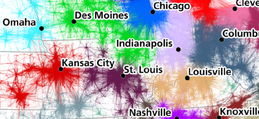
To divide the country into a mosaic of such megaregions, analysts typically rely on a loosely interpretive method which takes into account physical proximity, morphological integration, and cultural similarity, in order to group major and minor cities together with rural areas into coherent regional entities. In a recent paper, Garrett Dash Nelson and Alasdair Raepaper use a data set of more than 4,000,000 commuter flows as the basis for an empirical approach to the identification of such megaregions. The volume and resolution of this data set allows us to depict the interconnected nature of these labor markets at a national scale. The researchers use these flows in order to provide a rigorous and evidence-based assessment of whether megaregions exist and, if so, what spatial forms they take.
The authors compare a method which uses a visual heuristic for understanding areal aggregation to a method which uses a computational partitioning algorithm, and they reflect upon the strengths and limitations of both. The authors also discuss how choices about input parameters and scale of analysis can lead to different results, and stress the importance of comparing computational results with ‘common sense’ interpretations of geographic coherence.
The detection of recognizable communities through this computational analysis suggests that human geography does in fact display statistically-significant patterns of structured regionalization, and that this regionalization matches interpretive descriptions of megaregions. Such empirical analyses provide a scaffolding on which policymakers can evaluate the appropriate territorial shape and size of districts ranging from regional transit zones to electoral constituencies. However, we must be careful not to assume that an absolute or final structure of regional divisions can be determined.
Read the entire article:
Dash Nelson G, Rae A (2016) An Economic Geography of the United States: From Commutes to Megaregions. PLoS ONE 11(11): e0166083. https://doi.org/10.1371/journal.pone.0166083